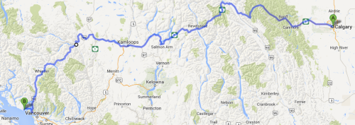
July 26, 2013: Calgary – Canmore, 110 km
I woke up excited. This was it. I’d been looking forward to the Rocky Mountains since I left NL, and seeing their faint silhouettes on the horizon was more than enough motivation to start tackling the first significant hills since Ontario.
As I headed west, the huge grassy fields of Alberta began to bunch up like a carpet, and the once straight highway started snaking its way between rapidly developing foothills. Sometimes, when riding, a curve is just a curve, but when it’s the first real curve in almost 2000 km, it takes on a special significance. The terrain was changing, and the road with it. No contour seemed superfluous, every hill logical and unavoidable.
The weather was different as well. The stuffy and temperamental humidity of the prairies was gone, and a cool mountain breeze had replaced it. Winnipeg sits at an elevation of 240 m, Calgary at just over 1000 m. The longest hill of the trip by far, though I never really felt it.
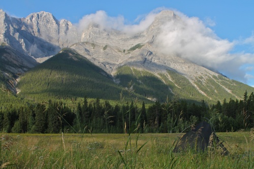
Soon, I was winding my way through Bow River Valley with densely forested hills nudging me left and right. Barren rocky peaks jutted out of their summits. Ancient fortresses. I was soon “that guy,” stopping every 5 minutes to take pictures.
I arrived in Canmore at dinner time, and set up my portable kitchen by the local rec centre. Dinner with a view. After a few conversations with some locals, and a greatly appreciated free beer courtesy of a travelling family, I started hunting around for a campsite. I was advised towards a local park by the river. Excellent. I was a bit apprehensive towards camping outside of town, since pretty much everyone I talked to about the mountains mentioned some sort of cautionary tale with respect to the wildlife. Ok, I get it. There are bears.
Just before I went to sleep, the park’s automated sprinkler system made itself known. Shit. Time to relocate. It was nearly midnight at this point, so I decided to stay within the park but away from the sprinklers. I found a semi-private spot next to the river and hastily moved all my gear. Rivers aren’t tidal, right? I shoved my food bag into a nearby animal-proof garbage can and quickly passed into dreams flooded with curious creatures and restless brooks.
July 27, 2013: Canmore
I woke up and immediately went to pick up my food pannier. It was gone! For about 30 seconds, I stood there doing nothing. What could I do? I remembered seeing a guy in the area about 5 minutes earlier. Maybe he saw them? I was shooting in the dark, but I had no other options. After leaving the park and walking down the road a bit, I spotted him, and in his hand was my bag. I ran after him and easily convinced him of the misunderstanding. After all, who would leave a BRAND NEW pannier full of UNSPOILED food, as well as a bag of TOILETRIES? As I calmed down and returned to my bike and tent, I decided to shoulder the blame; it was a garbage can, not a bear cache. I silently vowed to not be such a dumbass in the future.
I stayed an extra day in Canmore after meeting with a gal who invited me to come climbing with her and her friends. I’d heard many good things about the climbing in the area, and since pretty much every other climbing plan had been a bust, I couldn’t decline. Climbing was great, and another reminder that life wouldn’t cease to be fun one I finished my trip.
I set up my tent just outside Canmore in a field that sat below the Three Sisters. It was a common destination for mountain bikers and dog walkers, so I knew the area was generally safe, provided I was smart. The grass was rough and unkempt, practically guaranteeing that I wouldn’t see a sprinkler head pop up unannounced. Perhaps I was a tad paranoid. I left the fly off the tent and lost myself in the starry sky. I was alone with only the wind rustling the nearby trees to coddle me. It was peaceful.
July 28, 2013: Canmore – Banff, 31 km
I couldn’t pass on visiting Banff, even if it was only 31 km away, and so I leisurely packed up and ate breakfast before heading off on the Banff Legacy Trail: a car-free paved road between Canmore and Banff.
I arrived in Banff early and met with a friend of mine from NL. FINALLY. We had been leapfrogging since Kenora, ON. It was comical how close we had come to each other during our respective journeys. He was hitchhiking; I was pedalling. It was great to finally connect.
His friend generously offered his couch for me to crash on, and so with my accommodations in order and a good amount of daylight left, I hiked up Sulfur Mountain to get a good view of the area. 5.5 km and 1.5 hours later, I reached the summit. The landscape was beautiful and rugged. Huge forests perfectly draped themselves over endless mountain roots. Far-off peaks were still decorated with patches of snow. Distant thunderstorms (I guess they hadn’t completely disappeared) echoed through the valleys. Clouds sat contentedly between various ranges.
After chilling out at the top for a while, I reminded myself that I was above 2000 m elevation, and that I was actually pretty cold. I learned that the gondola – ridiculously expensive during operating hours – became free for those going down the mountain in early mornings and late evenings. Sweet. I headed back to town to meet Trevor at Tim’s. Sometimes, a good conversation and a tea mug warming the hands is enough to feel completely content. This was one of those times.
Sleeping was difficult, as the many locals and visitors partied late into the night. Like, really late. It was quite obnoxious.
July 29, 2013: Banff
I hadn’t planned on staying in Banff for an extra day, but a severe rainstorm came through the area, and with the temperature hovering around 5 C, I asked if it’d be ok if I stayed for another evening. It was, and spent most of the day sitting around doing nothing. I didn’t mind.
July 30, 2013: Banff – Golden, 141 km
My initial plan was to head to Lake Louise and spend a day there before going off to Golden. However, since I was rained delayed in Banff, I decided to make tracks and forego stopping in LL. Surely, there were plenty of mountain lakes in my future, and I was already tired of the tourist atmosphere.
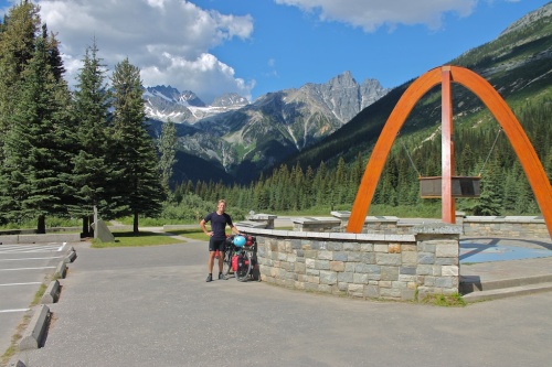
This was another big day for me: I was entering British Columbia, my homeland. As I made my way towards Kicking-Horse Pass – quite easy when coming from the east – I looked for an indication that I had changed provinces. There weren’t any: road-widening construction had removed all signs; I only realized that I was in BC once I reached the information centre in Field, BC, about 30 km past the border. It was now getting a bit late to ride another 60 km, but I knew the road was pretty much downhill from here to Golden, and so I carried on.
Sure enough, the ride down the valley was a speedy one, with only a few delays for uphills (and pictures, of course). I arrived in Golden fairly late, and set up camp behind a truck stop near the edge of town. No bugs harassed me, and it was heavenly.
Welcome to BC.
July 31, 2013: Golden – Revelstoke, 150 km
Today was going to be a tough one. 150 km is ambitious (but perfectly doable), but I knew I had Roger’s Pass to overcome, the only significant pass of the trip (or so I thought. more on that later). Odds were in my favour, though: I was about to change time zones, gaining an hour, and I already had a lock on accommodations in Revelstoke, a connection I made way back in White River, ON.
I have learned a lot about Canadian geography on this trip, but I was oblivious to the fact that there are two separate groups of mountain ranges that I was crossing (hence, two passes): the Rocky Mountains and the Columbia Mountains. Today’s trip took me across one of the Columbia ranges.
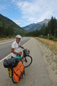
I always thought that Banff National Park had a monopoly on scenery and that BC was a bit shortchanged in the department of mountainous beauty. How wrong I was. Cycling through the Columbia Mountains, including Glacier National Park and Revelstoke National Park, was probably one of the most inspiring legs of my traverse so far. Although the Rockies were overwhelming in their grandeur and majesty, I always felt slightly detached from their immense proportions. The highway never came too close to them, and so they remained intangible and unrelatable. If life existed on their uninviting slopes, it was beyond my discernment.
The Columbia range was a completely different experience. The road closely hugged the steep and jagged roots, and each impressive hill was endlessly interesting. Peaks were capped with elegant powder. Waterfalls had eroded profound channels in the ancient shelves, and, along with firs, spruces, cedars, and pines, the slopes were home to dense sections of undergrowth. I must have had a huge grin on my face. The alpine cycles had revealed themselves, and I felt privileged to be witnessing them as a small and unaffecting traveller.
I met a dude who was biking from Salmon Arm to Medicine Hat “for work.” Quite the commute, but I guess he just couldn’t pass on an opportunity to cross the mountains via bicycle.
I arrived in Revelstoke early in the evening and quickly connected with my host. After a delicious indian curry (I guess the inspiration carried over), I crashed. What an excellent day.
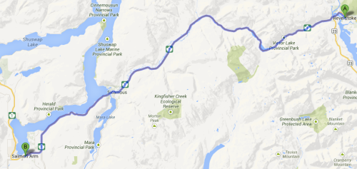
August 1, 2013: Revelstoke – Salmon Arm, 110 km
After spending at least 3 hours getting ready and procrastinating, I headed off towards Salmon Arm. My legs felt good, and I knew I was through the worst of the hills.
After an incredibly minor pass (which I was only aware of because of checking the map), I followed the meandering road through the Shuswap Valley and eventually alongside Shuswap Lake. I was out of the mountains now. Each forested hill no longer came to a sharp rocky peak but was blanketed densely and uniformly.
I met and travelled with another cyclist: Jack the American. He was doing a trip from Calgary to Vancouver, and we had been more or less stopping in the same places. We decided to bike together for a while. It was nice to have someone to talk to, but I quickly realized that I had become quite accustomed to solo travelling. My side of most conversations consistently degraded into one word answers, as I was not used to vocalizing my stream of consciousness. Maybe this is how solo travelling makes one weird? Whatever the case, when we finally arrived in SA, I returned to earth and it was great to have someone with whom to relate stories of adventure and serendipity.
Before hunting for a campsite, we checked out some live music in the town centre and met some local cyclists. After a brief conversation, they offered us their yard for camping. We enthusiastically accepted, and as the rain persisted and worsened, their yard offer became a house offer, and I ended up in a comfortable bed for the evening. The situation was slightly humourous, as both our tents sat in their backyard fully assembled yet unoccupied.
August 2, 2013: Salmon Arm – Kamloops, 110 km
Jack and I were both heading towards Kamloops, and so we started off together. The day was getting pretty warm, and as the landscape gradually became dryer, so did the air. I was heading into the badlands again, hopefully this time without the relentless storms.
We stopped about halfway in Chase for a swim and chilled out for a couple of hours. It was a beautiful day, and Kamloops wasn’t going anywhere. After several dips and an impromptu ride in a sport boat, we headed off.
25 km out of Kamloops, I spotted another tourist ahead on the shoulder, and I accelerated to catch up with him. Barri, it turns out, had been travelling from Toronto and was heading to Vancouver. As he elaborated on his itinerary, I was amazed at how many spots we had both crossed at near identical times, yet somehow without seeing each other. I guess that’s how it goes.
We all parted ways in Kamloops as I headed up the hill to meet some old friends from Victoria who had a place for me to stay at just out of town.
August 3, 2013: Kamloops
I did nothing noteworthy.
August 4, 2013: Kamloops – Cache Creek, 95 km
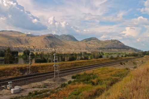
After another late start, I headed off into the now nearly completely desert landscape. It was hot, but dry hot air isn’t so bad, and there was a nice breeze. The hills became quite long and gradual, and because of the valley the highway was clinging to, I could often see many km down the road.
There was a stoic beauty to the terrain, as if everything I was seeing had earned its place through toil and hardship. The dry soil occasionally gave way to lumbering rocky protrusions. Plants armed themselves with protective thorns, and even the grass was coarse and resilient.
Back on the road after a brief swim in Savona, I realized I was biking alongside a rapidly approaching thunderstorm. The winds swept up with startling immediacy, and I soon found myself riding through a mix of thunder, hail, and rain. Fortunately, the storm only grazed me, and it gifted me with an excellent tailwind once it passed.
I made it to Cache Creek late in the afternoon. After a pleasant dinner in the local park, I set up camp behind a gas station. It was still quite warm, but not the slightest bit uncomfortable. Crickets sang me to sleep after a short and relatively event-free day.
August 5, 2013: Cache Creek – Lillooet, 85 km
Another shorter day was ahead, but I decided to set off early anyway. I knew it was going to be another warm day, and I wanted to avoid the brunt of the heat.
As I headed northwest, the hills became more populated with trees and vegetation, but everything still had an arid feel. The grass was mostly pale yellow, and the trees seemed inflexible and dehydrated.
Just about halfway to Lillooet, I passed through Marble Canyon and stopped at the nearby lake. It was so refreshing! I stayed for a couple of hours and swam several times. I also met an older couple from Ladysmith who were visiting the exact spot they had first encountered some 50 years earlier.
After leaving the Canyon I rounded a gradual bend in the road, passing Pavilion and coming up along the eastern bank of the Fraser Canyon. The vegetation once again disappeared as the scenery continued to evolve. Across the canyon, the dirt walls rose to impressive heights with small, grassy flatlands occasionally jutting out from their sides. Distant dirt roads connected small communities along the western bank, and the Fraser River churned violently just out of sight far below.
Just before entering into Lillooet, the river widened as well as the canyon, and slow turns in the road revealed breathtaking vistas. BC continued to marvel me with its variety of scenery. I couldn’t believe how little I knew about the province I was born in.
After a short stop in Lillooet, I headed up the road to a free campsite. Suddenly, I was in the mountains again, and small clearings in the trees revealed ugly stony peaks. I was amazed at how quickly the land had transformed and looked forward to some more time in the mountains as I approached the Pacific Ocean.
After a bath in a nearby glacial creek, I drifted off to sleep well before 10 pm. Several people I had talked to about heading to Pemberton had warned me of difficult hills ahead and few (actually, no) services, so I wanted an early and well-rested start.
August 6, 2013: Lillooet – Pemberton, 100 km
I set off just before 8 am with an additional 6L of water. My bike was probably at its heaviest, just what I needed for the terrain ahead. It was long until I encountered the first significant hill. Steep grade warning signs lined the road, and I knew I was in for it. Soon enough, I was struggling up 11-15% grades, and my granny gear, previously nearly unnecessary, became my best friend. It didn’t help that the road was not in the best condition, and blind corners were everywhere.
Lillooet sits at 200 m above sea level. As does Pemberton. However, the peak of this unmarked pass is at just over 1300 m, and the first 70 km of the trip were uphill. Occasionally, I would have a short reprieve, or even a small downhill, but because of the constant upward trend, the ups were always longer and steeper. I must have climbed 2 km in total.
Luckily, Duffy Lake was near the summit, and I was happy to have a swim break. I met a guy on his kayak who offered his yard to camp in once I reached Pemberton, and I happily accepted. I was sure to be exhausted by that point, and it was a relief to not have to think about finding a sneaky spot to pitch my tent.
After what seemed like an endless climb, I reached the top, and lost all of my elevation in 13 km. How anticlimactic. The descent was incredibly steep – up to 15% at times – and I could smell brake pads most of the way down. I hoped they weren’t mine.
After another swimming stop, I headed to John’s place, where he and his wife had planned on having me for dinner. What a nice surprise after an excruciating day. Their backyard was so soft, I didn’t bother with my sleeping pad. Just me, my tent, and my pillow. Summer nights can be incredibly therapeutic.
August 7, 2013: Pemberton – Squamish, 93 km
After a breakfast c.o. my hosts (thank you!), I was off. I was in for a steady climb towards Whistler, but I knew it’d be mostly downhill after that. Besides, my legs weren’t even remotely sore from the previous assault, so I was pretty confident.
Just as I arrived in Whistler, some road bikers invited me over for a smoothie, a welcome treat as the weather was just heating up. After, I headed into the village for a little while to relax. Whistler was full of righteous dudes and dudettes riding complex and expensive downhill mountain bikes. This was the first place I had visited where I figured my bike was probably the least valuable one around (including all the gear).
After a short swim in a nearby lake, I headed towards Squamish. Although I had been to Whistler in 2002, I had climbed in Squamish last year, and so it was still a familiar place to me. And so, with this segment, I was connecting the known with the newly conquered. I had unravelled the upper boundary of Highway 99, and in light of my familiarity with Squamish, I felt as a traveller returning from unknown and foreign lands. BC made a little bit more sense now, and as The Chief slowly overtook the horizon, I knew I was nearing the end of my trip.
I met a climber last year in Squamish, and he offered his couch for me to crash on, as well as his expertise in trad climbing. Time to shift gears for a couple of days.
August 8 – 9, 2013: Squamish
I climbed; it was fun. I may have done other things as well. Alex was an awesome host.
August 10, 2013: Squamish – Gibsons, 53 km (and a ferry!)
The Sea to Sky Highway was recently redone for the 2010 winter Olympics in Whistler, and the trip towards Horseshoe Bay was a beaut. Though the hills were often quite long and the wind was constantly in my face, I was finally getting a good glimpse of the coast and ocean. As I left the Squamish inlet, the ocean slowly changed from an milky aquamarine hue to a deep, rich navy blue. The trappings of home were all present: dense forests, white-capped waters. It was strange to think that I could be in Victoria in one day, yet I wouldn’t be for another couple of weeks. Everything felt familiar.
I surprised my grandma and aunt in Gibsons with my arrival. They didn’t think I was showing up for another couple of days. It was worth it.
Time for another long rest before the final 500 km. Thanks for stopping by!















I spent quite some time reading this and enjoying the photos. The section between Golden and Revelstoke is one of my absolutely favourite drives because of the scenery you described so well. Some spectacular pictures you got!
looking forward to seeing you in the not too distant future! Dad will be on his way shortly to meet up with you in Nanaimo. It still seems quite surreal that you have cycled across this vast country.
Mom
wowsers bowsers. first time i realized i could comment. almost there!